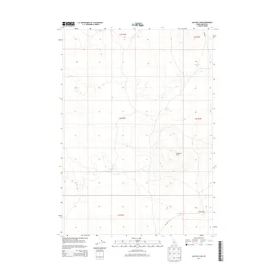
2013 Map of Halfway Lake
USGS Topo · Published 2013About this map
Wildhorse Butte rises as the dominant landmark in this high desert landscape of Idaho, situated within a topography marked by a series of seasonal basins and depressions. The 2013 survey of this Lincoln County region reveals a scattered network of water bodies, including Halfway Lake, Mud Flat Lake, and the eastern and western portions of the Wildhorse complex, specifically W Wildhorse Lake and S Wildhorse Lake. These ephemeral features suggest a landscape defined by periodic drainage and accumulation rather than permanent flow. Human activity is represented by the section lines of the Public Land Survey System and isolated transit routes such as Kimama Rd and Shale Butte Rd. The map illustrates the characteristic grid of southern Idaho ranching and range land, where large-scale administrative boundaries like t4s r22e and t4s r23e organize the territory around these natural desert landmarks.
Find a feature on this map
13 named features on this map. Tap any name to fly to it.
Don’t see what you’re looking for? This feature index may not catch every label — zoom into the map to look around manually.
Map Details
Editions of this 2013 Halfway Lake Map
This is the sole edition of this map. No revisions or reprints were ever made.
Other maps of this area

1954 · Pocatello
USGS Topo · 1:250,000

1955 · Idaho Falls
USGS Topo · 1:250,000

1958 · Idaho Falls
USGS Topo · 1:250,000

1958 · Pocatello
USGS Topo · 1:250,000

1972 · Shale Butte
USGS Topo · 1:24,000

1972 · Community Lake
USGS Topo · 1:24,000

1972 · Laidlaw Lake
USGS Topo · 1:24,000
1972 · Senter
USGS Topo · 1:24,000

1972 · Laidlaw Butte
USGS Topo · 1:24,000

1978 · Craters Of The Moon
USGS Topo · 1:100,000