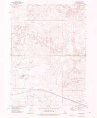
1972 Map of Senter
USGS Topo · Published 1976About this map
The Union Pacific railroad cuts a sharp diagonal across the high desert flats of southern Idaho, anchoring the remote outpost of Senter. This 1972 field-checked survey reveals an arid landscape where water management is the primary driver of human presence. Named water features like Antelope Reservoir, Carral Reservoir, and the twin basins of Sid Lake No 1 and Sid Lake No 2 are vital landmarks in an area otherwise defined by lava flows and sagebrush. Isolated infrastructure such as Clark Well, Well 4284, and a distributed Storage Bin reflect the region's ranching and transit requirements. The terrain is navigated by a network of primitive routes, including a prominent Firebreak and numerous Jeep Trails that crisscross the lava beds near North Center Lake.
Find a feature on this map
17 named features on this map. Tap any name to fly to it.
Don’t see what you’re looking for? This feature index may not catch every label — zoom into the map to look around manually.
Map Details
Editions of this 1972 Senter Map
This is the sole edition of this map. No revisions or reprints were ever made.
Other maps of this area

1954 · Pocatello
USGS Topo · 1:250,000

1955 · Idaho Falls
USGS Topo · 1:250,000

1955 · Twin Falls
USGS Topo · 1:250,000

1955 · Hailey
USGS Topo · 1:250,000

1958 · Twin Falls
USGS Topo · 1:250,000

1958 · Idaho Falls
USGS Topo · 1:250,000

1958 · Pocatello
USGS Topo · 1:250,000

1959 · Hailey
USGS Topo · 1:250,000

1962 · Hailey
USGS Topo · 1:250,000

1971 · Owinza
USGS Topo · 1:24,000