
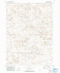
1971 Map of Owinza
USGS Topo · Published 1974About this map
The Union Pacific railroad cuts a straight line through the high desert landscape of Lincoln County, anchoring the small siding and settlement of Owinza. This 1971 survey reveals a region defined by water management and ranching infrastructure, where human activity is marked by isolated water sources and livestock improvements. In an area dominated by intricate contour lines and volcanic-like terrain, naming conventions like the Dietrich Allotment Well and Shirley G Spring suggest a landscape partitioned for grazing. Scattered catchments such as Monument Reservoir, East Monument Reservoir, and Banner Reservoir illustrate the essential role of water storage in this arid Idaho environment. Navigation through the complex topography is facilitated by a network of Firebreak clearings and Jeep Trail routes, providing a record of the backcountry access used by ranchers and surveyors during the early 1970s.
Find a feature on this map
10 named features on this map. Tap any name to fly to it.
Don’t see what you’re looking for? This feature index may not catch every label — zoom into the map to look around manually.
Map Details
Editions of this 1971 Owinza Map
2 editions found
Other maps of this area

1954 · Pocatello
USGS Topo · 1:250,000

1955 · Idaho Falls
USGS Topo · 1:250,000

1955 · Twin Falls
USGS Topo · 1:250,000

1955 · Hailey
USGS Topo · 1:250,000

1958 · Twin Falls
USGS Topo · 1:250,000

1958 · Idaho Falls
USGS Topo · 1:250,000

1958 · Pocatello
USGS Topo · 1:250,000

1959 · Hailey
USGS Topo · 1:250,000

1962 · Hailey
USGS Topo · 1:250,000

1971 · Star Lake
USGS Topo · 1:24,000