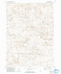
1971 Map of Owinza
USGS Topo · Published 1992About this map
Owinza sits along the southern corridor of this high desert landscape, defined by its position on the Union Pacific railroad. The environment is characterized by scattered water resources critical for cattle and land management, including the Dietrich Allotment Well WT and several distinct reservoirs such as Monument Reservoir, East Monument Reservoir, and Banner Reservoir. The terrain is marked by ephemeral features like Rock Lake and named water sources like Shirley G Spring, reflecting the pastoral and transit-focused nature of Lincoln County during this era. While primarily open land, the concentration of benchmarks and wells around the rail line suggests the continued importance of this transportation artery to the regional economy and local hydrology.
Find a feature on this map
10 named features on this map. Tap any name to fly to it.
Don’t see what you’re looking for? This feature index may not catch every label — zoom into the map to look around manually.
Map Details
Editions of this 1971 Owinza Map
2 editions found

Other maps of this area

1954 · Pocatello
USGS Topo · 1:250,000

1955 · Idaho Falls
USGS Topo · 1:250,000

1955 · Twin Falls
USGS Topo · 1:250,000

1955 · Hailey
USGS Topo · 1:250,000

1958 · Twin Falls
USGS Topo · 1:250,000

1958 · Idaho Falls
USGS Topo · 1:250,000

1958 · Pocatello
USGS Topo · 1:250,000

1959 · Hailey
USGS Topo · 1:250,000

1962 · Hailey
USGS Topo · 1:250,000

1971 · Star Lake
USGS Topo · 1:24,000