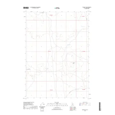
2020 Map of Halfway Lake
USGS Topo · Published 2020About this map
Snake River Plains topography dominates this section of Lincoln County, characterized by a series of intermittent lake beds and prominent volcanic rises. The landscape is defined by its drainage patterns, notably the cluster of ephemeral waters including Halfway Lake, West Wildhorse Lake, and South Wildhorse Lake. These features, along with Mud Flat Lake in the northeastern corner, suggest a terrain where water collection is dictated by the subtle depressions of the basaltic plain. Elevation changes are most pronounced at Wildhorse Butte and Sand Butte, which serve as primary landmarks in an otherwise open expanse. The area is intersected by a sparse network of local tracks such as Kamimah Rd and Shale Butte Rd, reflecting the remote, high-desert character of this portion of southern Idaho as it appeared during the 2020 survey.
Find a feature on this map
15 named features on this map. Tap any name to fly to it.
Don’t see what you’re looking for? This feature index may not catch every label — zoom into the map to look around manually.
Map Details
Editions of this 2020 Halfway Lake Map
This is the sole edition of this map. No revisions or reprints were ever made.
Other maps of this area

1954 · Pocatello
USGS Topo · 1:250,000

1955 · Idaho Falls
USGS Topo · 1:250,000

1958 · Idaho Falls
USGS Topo · 1:250,000

1958 · Pocatello
USGS Topo · 1:250,000

1972 · Shale Butte
USGS Topo · 1:24,000

1972 · Community Lake
USGS Topo · 1:24,000

1972 · Laidlaw Lake
USGS Topo · 1:24,000
1972 · Senter
USGS Topo · 1:24,000

1972 · Laidlaw Butte
USGS Topo · 1:24,000

1978 · Craters Of The Moon
USGS Topo · 1:100,000