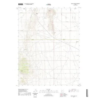
2020 Map of Halfway Summit
USGS Topo · Published 2020About this map
Halfway Summit stands as a central navigation point in this high-desert landscape, marking the transition between Antelope Valley and the expansive Pine Valley to the east. The terrain is defined by the Halfway Hills and the prominent Warm Cove Ridge, where topographic relief reveals the structural geology of the region. This 2020 survey records a network of numbered section roads, such as S 29800 West St, providing access to isolated water sources and geologic landmarks.
Find a feature on this map
25 named features on this map. Tap any name to fly to it.
Don’t see what you’re looking for? This feature index may not catch every label — zoom into the map to look around manually.
Map Details
Editions of this 2020 Halfway Summit Map
This is the sole edition of this map. No revisions or reprints were ever made.
Other maps of this area

1953 · Richfield
USGS Topo · 1:250,000

1958 · Richfield
USGS Topo · 1:250,000

1960 · Wah Wah Summit
USGS Topo · 1:62,500

1971 · Mountain Home Pass
USGS Topo · 1:24,000

1971 · Halfway Summit
USGS Topo · 1:24,000

1971 · Tunnel Spring
USGS Topo · 1:24,000

1971 · Sawtooth Peak
USGS Topo · 1:24,000

1971 · Lamerdorf Peak NW
USGS Topo · 1:24,000

1971 · Mormon Gap
USGS Topo · 1:24,000
1972 · Lopers Spring
USGS Topo · 1:24,000