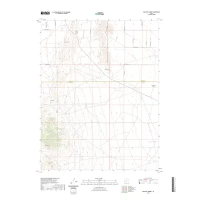
2023 Map of Halfway Summit
USGS Topo · Published 2023About this map
The high-desert terrain of Millard Co and Beaver Co meets along a remote mountainous stretch defined by dramatic elevation changes. Centered on Halfway Summit, the landscape transitions from the flat expanse of Antelope Valley in the northwest to the rugged Halfway Hills. Essential water sources for this arid region are marked as isolated points, including Beers Tunnel Spring, Pine Spring, and Upper Pine Spring, reflecting the critical importance of spring sites in the Great Basin.
Find a feature on this map
24 named features on this map. Tap any name to fly to it.
Don’t see what you’re looking for? This feature index may not catch every label — zoom into the map to look around manually.
Map Details
Editions of this 2023 Halfway Summit Map
This is the sole edition of this map. No revisions or reprints were ever made.
Other maps of this area

1953 · Richfield
USGS Topo · 1:250,000

1958 · Richfield
USGS Topo · 1:250,000

1960 · Wah Wah Summit
USGS Topo · 1:62,500

1971 · Mountain Home Pass
USGS Topo · 1:24,000

1971 · Halfway Summit
USGS Topo · 1:24,000

1971 · Tunnel Spring
USGS Topo · 1:24,000

1971 · Sawtooth Peak
USGS Topo · 1:24,000

1971 · Lamerdorf Peak NW
USGS Topo · 1:24,000

1971 · Mormon Gap
USGS Topo · 1:24,000
1972 · Lopers Spring
USGS Topo · 1:24,000