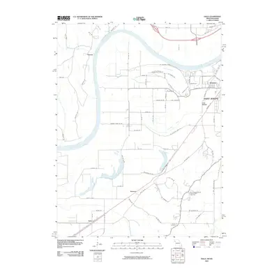
2009 Map of Halls
USGS Topo · Published 2009About this map
The Missouri River dominates the western half of this landscape, its wide meander defining the border between Missouri and Kansas. Along its eastern banks, the southern outskirts of Saint Joseph show a complex network of wetlands and oxbow lakes, including Lake Contrary, Muskrat Lake, and Horseshoe Lake. These water bodies suggest the river's historical shifts, now surrounded by a mix of industrial sites like the Farmland Industries Incorporated Lake Dam and established residential pockets.
Find a feature on this map
79 named features on this map. Tap any name to fly to it.
Don’t see what you’re looking for? This feature index may not catch every label — zoom into the map to look around manually.
Map Details
Editions of this 2009 Halls Map
This is the sole edition of this map. No revisions or reprints were ever made.
Other maps of this area

1885 · Atchison
USGS Topo · 1:125,000

1888 · Atchison
USGS Topo · 1:125,000

1893 · Atchison
USGS Topo · 1:125,000

1924 · St. Joseph
USGS Topo · 1:62,500

1926 · Atchison
USGS Topo · 1:62,500

1926 · Saint Joseph
USGS Topo · 1:62,500

1926 · Oregon
USGS Topo · 1:62,500

1927 · Dearborn
USGS Topo · 1:62,500

1950 · Kansas City
USGS Topo · 1:250,000
1951 · De Kalb
USGS Topo · 1:24,000