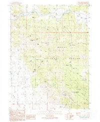
1990 Map of Halls Canyon
USGS Topo · Published 1990About this map
The Pit River winds through the northern reaches of this territory, carving a path alongside Ostrom Point and Cat Hill before entering the high-elevation terrain of the Modoc National Forest. This 1990 edition records a landscape defined by its water sources and ridges, where isolated points of interest like a Lookout Tower on Fox Mountain provided vantage over the surrounding timber and canyons. The presence of numerous named water sources, including Andrews Spring, Nichols Spring, and Deep Cut Spring, indicates the critical role of reliable springs in this high-country environment.
Find a feature on this map
51 named features on this map. Tap any name to fly to it.
Don’t see what you’re looking for? This feature index may not catch every label — zoom into the map to look around manually.
Map Details
Editions of this 1990 Halls Canyon Map
This is the sole edition of this map. No revisions or reprints were ever made.
Other maps of this area

1886 · Alturas
USGS Topo · 1:250,000

1886 · Modoc Lava Bed
USGS Topo · 1:250,000

1892 · Modoc Lava-Bed
USGS Topo · 1:250,000

1892 · Alturas
USGS Topo · 1:250,000

1954 · Alturas
USGS Topo · 1:250,000

1958 · Alturas
USGS Topo · 1:250,000

1961 · Canby
USGS Topo · 1:62,500

1961 · Bieber
USGS Topo · 1:62,500

1962 · Alturas
USGS Topo · 1:250,000

1962 · Crank Mountain
USGS Topo · 1:62,500