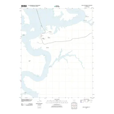
2011 Map of Halls Crossing
USGS Topo · Published 2011About this map
Halls Crossing and its adjacent recreational infrastructure center this survey of the eastern shores of Lake Powell. The map illustrates a developed gateway for travelers, featuring the Halls Crossing Marina and the John Atlantic Burr Ferry, which provides a vital water link across the reservoir. Nearby services include the Halls Crossing Airport, as well as the Halls Crossing Campground and Halls Crossing RV Campground, reflecting the area's role as a primary access point for the Glen Canyon National Recreation Area.
Find a feature on this map
14 named features on this map. Tap any name to fly to it.
Don’t see what you’re looking for? This feature index may not catch every label — zoom into the map to look around manually.
Map Details
Editions of this 2011 Halls Crossing Map
This is the sole edition of this map. No revisions or reprints were ever made.
Other maps of this area

1886 · Henry Mountains
USGS Topo · 1:250,000

1892 · Henry Mountains
USGS Topo · 1:250,000

1953 · The Rincon
USGS Topo · 1:62,500

1953 · Lake Canyon
USGS Topo · 1:62,500

1953 · Mt. Ellsworth
USGS Topo · 1:62,500

1953 · Hall Mesa
USGS Topo · 1:62,500

1956 · Escalante
USGS Topo · 1:250,000

1960 · Escalante
USGS Topo · 1:250,000
1980 · Hite Crossing
USGS Topo · 1:100,000
1981 · Navajo Mountain
USGS Topo · 1:100,000