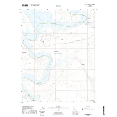
2020 Map of Halls Crossing
USGS Topo · Published 2020About this map
Lake Powell dominates this high-desert landscape where the waters of the Colorado River meet the intricate carved canyons of the Glen Canyon National Recreation Area. The settlement of Halls Crossing serves as a critical access point for the region, connected by Halls Crossing Rd and positioned near the expansive Bullfrog Bay. The map reveals a complex geography of flooded drainage systems, including Moqui Canyon and Lake Canyon, which illustrate the transformation of the canyon floor into a reservoir environment. Uplands such as Iron Top Mesa and the Red Rock Plateau stand above the water line, marking the original elevation of the plateau. The boundary between San Juan and Kane Counties snakes through the water, tracing the historic path of the river through Glen Canyon.
Find a feature on this map
17 named features on this map. Tap any name to fly to it.
Don’t see what you’re looking for? This feature index may not catch every label — zoom into the map to look around manually.
Map Details
Editions of this 2020 Halls Crossing Map
This is the sole edition of this map. No revisions or reprints were ever made.
Other maps of this area

1886 · Henry Mountains
USGS Topo · 1:250,000

1892 · Henry Mountains
USGS Topo · 1:250,000

1953 · The Rincon
USGS Topo · 1:62,500

1953 · Lake Canyon
USGS Topo · 1:62,500

1953 · Mt. Ellsworth
USGS Topo · 1:62,500

1953 · Hall Mesa
USGS Topo · 1:62,500

1956 · Escalante
USGS Topo · 1:250,000

1960 · Escalante
USGS Topo · 1:250,000
1980 · Hite Crossing
USGS Topo · 1:100,000
1981 · Navajo Mountain
USGS Topo · 1:100,000