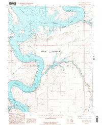
1987 Map of Halls Crossing
USGS Topo · Published 1987About this map
Lake Powell dominates the landscape in this mid-1980s provisional study, filling the deep carved channels of Glen Canyon along the border of San Juan and Kane Counties. The map captures the infrastructure of the Glen Canyon National Recreation Area during a period of established recreational use, detailing the Halls Crossing hub with its Airport, Campground, and Boat Docks. While the modern reservoir defines the geography, older layers of movement remain visible through the Emigrant Trail (Ifack) winding through the high desert terrain. The transition from the flowing Colorado River to the still waters of Bullfrog Bay and Halls Creek Bay illustrates the dramatic transformation of this canyon system. Notable landforms like Iron Top Mesa and the branching reaches of Moqui Canyon provide a stark contrast to the developed marina facilities at the water's edge.
Find a feature on this map
21 named features on this map. Tap any name to fly to it.
Don’t see what you’re looking for? This feature index may not catch every label — zoom into the map to look around manually.
Map Details
Editions of this 1987 Halls Crossing Map
This is the sole edition of this map. No revisions or reprints were ever made.
Other maps of this area

1886 · Henry Mountains
USGS Topo · 1:250,000

1892 · Henry Mountains
USGS Topo · 1:250,000

1953 · The Rincon
USGS Topo · 1:62,500

1953 · Lake Canyon
USGS Topo · 1:62,500

1953 · Mt. Ellsworth
USGS Topo · 1:62,500

1953 · Hall Mesa
USGS Topo · 1:62,500

1956 · Escalante
USGS Topo · 1:250,000

1960 · Escalante
USGS Topo · 1:250,000
1980 · Hite Crossing
USGS Topo · 1:100,000
1981 · Navajo Mountain
USGS Topo · 1:100,000