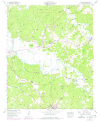
1950 Map of Halltown
USGS Topo · Published 1977About this map
Free Dom Hills and the winding course of Bear Creek define this Franklin County landscape during the mid-century era. The map documents a transition between upland ridges and the fertile bottoms where agriculture and timbering shaped local life. A network of small settlements like Seven Pines, Halltown, and Burntout are connected by rural routes, including the historic Cotton Gin Road and Old Cotton Gin Road. The Illinois Central Gulf Railroad provides a critical industrial corridor, serving the town of Vina and the northern edge of Red Bay.
Find a feature on this map
73 named features on this map. Tap any name to fly to it.
Don’t see what you’re looking for? This feature index may not catch every label — zoom into the map to look around manually.
Map Details
Editions of this 1950 Halltown Map
This is the sole edition of this map. No revisions or reprints were ever made.
Other maps of this area

1925 · Barton
USGS Topo · 1:62,500

1926 · Barton
USGS Topo · 1:48,000

1929 · Barton
USGS Topo · 1:62,500

1935 · Pleasant Site
USGS Topo · 1:24,000

1936 · Belmont
USGS Topo · 1:24,000

1936 · Pleasant Grove
USGS Topo · 1:24,000

1936 · Hodges
USGS Topo · 1:24,000

1936 · Red Bay
USGS Topo · 1:24,000

1936 · Vina
USGS Topo · 1:24,000

1936 · Halltown
USGS Topo · 1:24,000