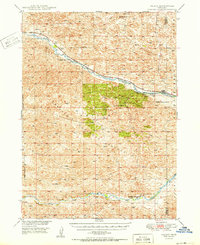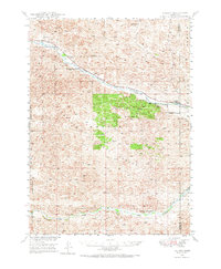
1948 Map of Halsey
USGS Topo · Published 1973About this map
The Nebraska National Forest dominates the center of this 1940s landscape, illustrating a massive effort at timber cultivation within the Sandhills. This high-plains environment is defined by the parallel paths of the Middle Loup River to the north and the Dismal River along the southern edge. The small settlement of Halsey serves as the primary gateway to the forest, while the Chicago Burlington and Quincy railroad follows the river valley, connecting the ranching country to wider markets. Land-use patterns here reveal the specialized infrastructure of the Bessey Ranger District, including the Nursery and the Scott Lookout Tower. Further north, isolated markers of rural life like the Rose Hill Sch and the siding at Natick emphasize the sparse but organized settlement of Thomas and Blaine counties before mid-century modernizations.
Find a feature on this map
12 named features on this map. Tap any name to fly to it.
Don’t see what you’re looking for? This feature index may not catch every label — zoom into the map to look around manually.
Map Details
Editions of this 1948 Halsey Map
This is the sole edition of this map. No revisions or reprints were ever made.
Historical Maps of Halsey Through Time
7 maps found