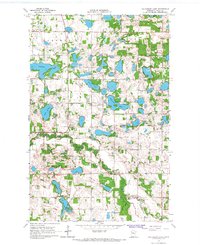
1966 Map of Halverson Lake
USGS Topo · Published 1967About this map
Halverson Lake sits at the heart of this Polk County landscape, which is characterized by a dense concentration of glacial kettles and basins. In the mid-1960s, the townships of Godfrey, Woodside, and Garfield maintained a traditional rural infrastructure of section-line roads and widely spaced homesteads. The Sand Hill River cuts a distinct valley through the southern half of the quadrangle, providing a sharp contrast to the flatter upland plains to the north. Local history and genealogy interests are anchored by features like the Cem and a Townhall located near the eastern boundary. Several smaller bodies of water, including Kittleson Lake, Lake Arthur, and Maple Lake, are surrounded by woodland patches and numerous Gravel Pits, indicating the area's geological reliance on glacial deposits. The map captures a quiet era of agricultural and recreational use before later land developments altered the northern Minnesota prairie-forest margin.
Find a feature on this map
18 named features on this map. Tap any name to fly to it.
Don’t see what you’re looking for? This feature index may not catch every label — zoom into the map to look around manually.
Map Details
Editions of this 1966 Halverson Lake Map
This is the sole edition of this map. No revisions or reprints were ever made.
Other maps of this area

1918 · Twin Valley
USGS Topo · 1:62,500

1919 · Valley
USGS Topo · 1:62,500

1952 · Grand Forks
USGS Topo · 1:250,000

1956 · Grand Forks
USGS Topo · 1:250,000

1965 · Dugdale
USGS Topo · 1:24,000

1965 · Fertile
USGS Topo · 1:24,000

1965 · Flaming
USGS Topo · 1:24,000

1966 · Grand Forks
USGS Topo · 1:250,000

1966 · Union Lake
USGS Topo · 1:24,000
1966 · Ranum
USGS Topo · 1:24,000