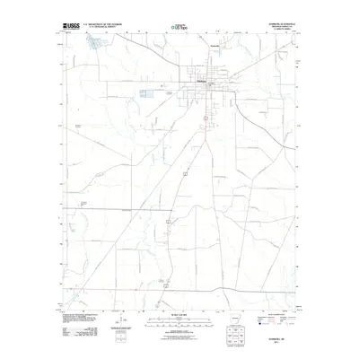
2011 Map of Hamburg
USGS Topo · Published 2011About this map
The county seat of Hamburg serves as the central hub of this South Arkansas landscape, defined by its traditional grid and key public landmarks like the Hamburg Post Office. To the north, the smaller community of Martinville sits near the upper reaches of the map. The terrain is crisscrossed by a network of drainage systems, most notably Chemin-A-Haut Creek and Hanks Creek, which influence the local geography and road placement. For those researching family history, several burial sites are documented across the quadrangle, including Antioch Cemetery in the south, Evergreen Cemetery to the west, and the centrally located Hamburg Cemetery. Large tracts of land between these settlements are accessed by a dense grid of rural routes, such as Ashley Road 12 W and Ashley Road 418, reflecting the area's agricultural and timber-based spatial organization.
Find a feature on this map
66 named features on this map. Tap any name to fly to it.
Don’t see what you’re looking for? This feature index may not catch every label — zoom into the map to look around manually.
Map Details
Editions of this 2011 Hamburg Map
This is the sole edition of this map. No revisions or reprints were ever made.
Other maps of this area

1935 · Mist
USGS Topo · 1:62,500

1935 · Wilmot
USGS Topo · 1:62,500

1952 · Fountain Hill
USGS Topo · 1:24,000

1953 · Greenwood
USGS Topo · 1:250,000

1956 · Greenwood
USGS Topo · 1:250,000

1960 · Mist
USGS Topo · 1:62,500

1960 · Wilmot
USGS Topo · 1:62,500

1960 · Wilmot NW
USGS Topo · 1:24,000
1960 · Mist
USGS Topo · 1:24,000
1960 · Wilmot SW
USGS Topo · 1:24,000