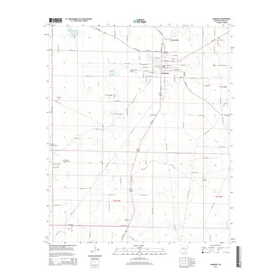
2014 Map of Hamburg
USGS Topo · Published 2014About this map
Hamburg serves as the central hub of this 2014 Ashley County study, showing the detailed street grid of the town center from W Washington St to E Jefferson St. The landscape beyond the town is defined by a network of waterways and rural burial grounds, including the Hamburg Cem and the more remote Antioch Cem to the south. Local aviation and recreation are represented by the M Jack Stell Field Airport and Pinewood Memorial Park on the western edge of the settlement. To the north, the small community of Martinville sits near the junction of several regional routes. The map provides a clear look at the drainage patterns of the region, where Hanks Cr and Chemin-A-Haut Cr wind through the timberlands and fields of southern Arkansas, illustrating the area's transition between developed town life and its agricultural roots.
Find a feature on this map
92 named features on this map. Tap any name to fly to it.
Don’t see what you’re looking for? This feature index may not catch every label — zoom into the map to look around manually.
Map Details
Editions of this 2014 Hamburg Map
This is the sole edition of this map. No revisions or reprints were ever made.
Other maps of this area

1935 · Mist
USGS Topo · 1:62,500

1935 · Wilmot
USGS Topo · 1:62,500

1952 · Fountain Hill
USGS Topo · 1:24,000

1953 · Greenwood
USGS Topo · 1:250,000

1956 · Greenwood
USGS Topo · 1:250,000

1960 · Mist
USGS Topo · 1:62,500

1960 · Wilmot
USGS Topo · 1:62,500

1960 · Wilmot NW
USGS Topo · 1:24,000
1960 · Mist
USGS Topo · 1:24,000
1960 · Wilmot SW
USGS Topo · 1:24,000