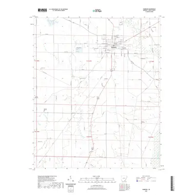
2020 Map of Hamburg
USGS Topo · Published 2020About this map
The Ashley County Courthouse stands as the central landmark of Hamburg, the county seat of Ashley County. This survey of the surrounding Arkansas Delta landscape captures a community defined by its grid of residential streets and localized burial grounds, including the Hamburg Cem and Evergreen Cem. The terrain is drained by several meandering waterways such as Hanks Cr and the unusually named Chemin-A-Haut Cr, which reflect the area's mixed heritage and low-lying geography. Further south, the rural character persists with scattered sites like Antioch Cem and the Pleasant Grove Cem, connected by a network of county roads like Co Rd 97 and State Hwy 52. The presence of Z M Jack Stell Field and Pinewood Memorial Park illustrates the mix of municipal infrastructure and community spaces that anchor this portion of the Arkansas timber and agricultural region.
Find a feature on this map
95 named features on this map. Tap any name to fly to it.
Don’t see what you’re looking for? This feature index may not catch every label — zoom into the map to look around manually.
Map Details
Editions of this 2020 Hamburg Map
This is the sole edition of this map. No revisions or reprints were ever made.
Other maps of this area

1935 · Mist
USGS Topo · 1:62,500

1935 · Wilmot
USGS Topo · 1:62,500

1952 · Fountain Hill
USGS Topo · 1:24,000

1953 · Greenwood
USGS Topo · 1:250,000

1956 · Greenwood
USGS Topo · 1:250,000

1960 · Mist
USGS Topo · 1:62,500

1960 · Wilmot
USGS Topo · 1:62,500

1960 · Wilmot NW
USGS Topo · 1:24,000
1960 · Mist
USGS Topo · 1:24,000
1960 · Wilmot SW
USGS Topo · 1:24,000