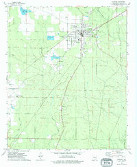
1973 Map of Hamburg
USGS Topo · Published 1975About this map
The town of Hamburg serves as the focal point of this Ashley County landscape in the early 1970s, characterized by its grid of residential streets and civic institutions like the County Fairground. Transportation and industry define the area's periphery, with the Missouri Pacific railroad line cutting through the north while an Old RR Grade remains visible to the south. The presence of several aquaculture operations, labeled simply as Fish Farm, indicates the local importance of commercial fish production during this era.
Find a feature on this map
30 named features on this map. Tap any name to fly to it.
Don’t see what you’re looking for? This feature index may not catch every label — zoom into the map to look around manually.
Map Details
Editions of this 1973 Hamburg Map
This is the sole edition of this map. No revisions or reprints were ever made.
Other maps of this area

1935 · Mist
USGS Topo · 1:62,500

1935 · Wilmot
USGS Topo · 1:62,500

1952 · Fountain Hill
USGS Topo · 1:24,000

1953 · Greenwood
USGS Topo · 1:250,000

1956 · Greenwood
USGS Topo · 1:250,000

1960 · Mist
USGS Topo · 1:62,500

1960 · Wilmot
USGS Topo · 1:62,500

1960 · Wilmot NW
USGS Topo · 1:24,000
1960 · Mist
USGS Topo · 1:24,000
1960 · Wilmot SW
USGS Topo · 1:24,000