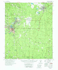
1978 Map of Hamburg
USGS Topo · Published 1978About this map
Hamburg serves as the focal point for this late 1970s survey, showing the established town grid near the Hamburg Cemetery and the industrial activity centered around Crossett. The landscape is a network of timberlands and drainage systems, defined by the winding paths of Chemin-A-Haut Creek and the various forks of Brushy Creek. The timber industry's footprint is evident in the numerous railroad alignments, including the Missouri Pacific and several sections marked as old railroad grade, which once connected outlying settlements like Whitlow Junction and Rolfe Junction.
Find a feature on this map
71 named features on this map. Tap any name to fly to it.
Don’t see what you’re looking for? This feature index may not catch every label — zoom into the map to look around manually.
Map Details
Editions of this 1978 Hamburg Map
This is the sole edition of this map. No revisions or reprints were ever made.
Other maps of this area

1934 · Ingalls
USGS Topo · 1:48,000

1934 · Felsenthal
USGS Topo · 1:62,500

1935 · Mist
USGS Topo · 1:62,500

1935 · Wilmot
USGS Topo · 1:62,500

1935 · Naff
USGS Topo · 1:62,500

1935 · Bonita
USGS Topo · 1:62,500

1935 · Haile
USGS Topo · 1:62,500

1937 · Felsenthal
USGS Topo · 1:62,500

1937 · Ingalls
USGS Topo · 1:62,500

1938 · Felsenthal
USGS Topo · 1:62,500