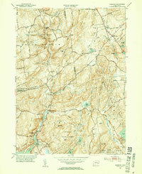
1952 Map of Hamburg
USGS Topo · Published 1954About this map
Devils Hopyard State Park and the rugged woodland of the Nehantic State Forest dominate this landscape during the early 1950s. The region is characterized by small, dispersed rural settlements and a significant concentration of family burial grounds, such as Whittlesey Cem, Sisson Cem, and Griffin Cem, indicating long-standing generational ties to the land. The Eightmile River flows southward through the terrain, passing the community of North Lyme toward the village of Hamburg, where it meets the falls.
Find a feature on this map
65 named features on this map. Tap any name to fly to it.
Don’t see what you’re looking for? This feature index may not catch every label — zoom into the map to look around manually.
Map Details
Editions of this 1952 Hamburg Map
3 editions found
Other maps of this area

1892 · New London
USGS Topo · 1:62,500

1892 · Norwich
USGS Topo · 1:62,500

1892 · Gilead
USGS Topo · 1:62,500

1893 · New London
USGS Topo · 1:62,500

1893 · Saybrook
USGS Topo · 1:62,500

1921 · New London
USGS Topo · 1:62,500

1934 · Niantic
USGS Topo · 1:24,000

1935 · Montville
USGS Topo · 1:24,000

1938 · Niantic
USGS Topo · 1:62,500

1939 · Montville
USGS Topo · 1:31,680