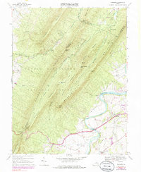
1967 Map of Hamburg
USGS Topo · Published 1985About this map
The South Fork Shenandoah River carves a sweeping path through Page County in this 1967 survey, where a series of tight loops define the local topography and settlement patterns. The map documents the valley's cultural landscape at a time when small rural clusters like Hamburg and Salem remained distinct from larger regional growth. Along the river, Whitehouse Landing and a Gaging Sta mark the historical relationship with the waterway, while the uplands are dominated by the massive ridges of the George Washington National Forest. Notable landmarks of community life include the Mill Creek Ch and Woods Chapel, alongside recreation sites such as Caroline Furnace Camp and Camp Roosevelt Recreation Area. The presence of several Quarries and a Gravel Pit near the river suggests the extraction industries that supported local infrastructure. To the west, the formidable terrain of Massanutten Mountain rises, broken only by gaps like New Market Gap, which historically facilitated transit through the Shenandoah Valley.
Find a feature on this map
53 named features on this map. Tap any name to fly to it.
Don’t see what you’re looking for? This feature index may not catch every label — zoom into the map to look around manually.
Map Details
Editions of this 1967 Hamburg Map
Other maps of this area

1892 · Woodstock
USGS Topo · 1:125,000

1893 · Luray
USGS Topo · 1:125,000

1905 · Luray
USGS Topo · 1:125,000

1923 · Edinburg
USGS Topo · 1:62,500

1929 · Stony Man
USGS Topo · 1:48,000

1933 · Stony Man
USGS Topo · 1:62,500

1942 · Mt Jackson
USGS Topo · 1:62,500

1946 · Mt Jackson
USGS Topo · 1:62,500

1947 · Mt Jackson
USGS Topo · 1:62,500

1947 · Strasburg
USGS Topo · 1:62,500