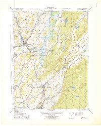
1943 Map of Hamburg
USGS Topo · Published 1944About this map
The Wallkill River corridor in Sussex County is defined here by a heavy concentration of early 1940s industry and transport, where the Lehigh and Hudson River RR and Lehigh and New England RR converge near Franklin. This era shows a landscape of extraction and production, with numerous Stone Quarries and a Sand Quarry scattered along the slopes of Hamburgh Mountain. The settlement of Sussex serves as a hub, supporting local operations like the Alderney Milk & Cream Co and serving as a junction for the New York Susquehanna and Western RR. Rural life is preserved through several township schools, including Wantage TWS School and Hardiston TWS School, while the presence of Fairview Cemetery and N Hardiston Cemetery provides valuable data for genealogical research into the families of the Wallkill and Vernon Valley.
Find a feature on this map
50 named features on this map. Tap any name to fly to it.
Don’t see what you’re looking for? This feature index may not catch every label — zoom into the map to look around manually.
Map Details
Editions of this 1943 Hamburg Map
This is the sole edition of this map. No revisions or reprints were ever made.
Other maps of this area

1888 · Franklin
USGS Topo · 1:62,500

1891 · Greenwood Lake
USGS Topo · 1:62,500

1893 · Greenwood Lake
USGS Topo · 1:62,500

1894 · Franklin
USGS Topo · 1:62,500

1897 · Franklin
USGS Topo · 1:62,500

1903 · Franklin Furnace
USGS Topo · 1:62,500

1903 · Greenwood Lake
USGS Topo · 1:62,500

1906 · Port Jervis
USGS Topo · 1:62,500

1906 · Goshen
USGS Topo · 1:62,500

1908 · Goshen
USGS Topo · 1:62,500
Featured Places
- Vernon Township, NJ
- Wantage, NJ
- Wantage Township, Vernon Township
- Franklin, Hardyston Township
- Hamburg, Hardyston Township