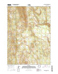
2014 Map of Hamelton Butte
USGS Topo · Published 2014About this map
High-altitude drainage patterns in this corner of Klamath County and Lake County center on the headwaters of Long Cr, which flows north through the heart of the township. The terrain is characterized by a complex network of seasonal and perennial watercourses, including Calchan Cr in the northeast. While the map is sparse of named settlements, the intricate contour data reveals the underlying volcanic and tectonic morphology of this high-elevation region, showing how the natural drainage systems are funneled through the local topography.
Find a feature on this map
2 named features on this map. Tap any name to fly to it.
Don’t see what you’re looking for? This feature index may not catch every label — zoom into the map to look around manually.
Map Details
Editions of this 2014 Hamelton Butte Map
This is the sole edition of this map. No revisions or reprints were ever made.
Other maps of this area

1889 · Klamath
USGS Topo · 1:250,000

1894 · Klamath
USGS Topo · 1:250,000

1955 · Klamath Falls
USGS Topo · 1:250,000

1958 · Klamath Falls
USGS Topo · 1:250,000

1960 · Riverbed Butte
USGS Topo · 1:62,500

1960 · Sycan Marsh
USGS Topo · 1:62,500

1960 · Fuego Mountain
USGS Topo · 1:62,500

1960 · Yamsay Mountain
USGS Topo · 1:62,500

1980 · Williamson River
USGS Topo · 1:100,000
1988 · Sycan Marsh West
USGS Topo · 1:24,000