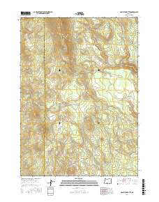
2017 Map of Hamelton Butte
USGS Topo · Published 2017About this map
Hamelton Butte and the high terrain of Booth Ridge dominate this section of the Oregon Cascades, situated along the county line where Klamath Co meets Lake County. The landscape is defined by its drainage systems and high-elevation meadows, with Long Cr and Callahan Cr flowing through the northern reaches of the quadrangle. Central to the map, Stratton Meadow sits just north of the Sand Cr corridor, while the southern terrain is marked by Echo Spring and the intermittent flow of Dry Cr. This 2017 survey provides a detailed view of the forest roads and topography in a region where water sources like these springs and creeks were vital markers for early land management and navigation through the timber-rich ridges of the southern interior.
Find a feature on this map
13 named features on this map. Tap any name to fly to it.
Don’t see what you’re looking for? This feature index may not catch every label — zoom into the map to look around manually.
Map Details
Editions of this 2017 Hamelton Butte Map
This is the sole edition of this map. No revisions or reprints were ever made.
Other maps of this area

1889 · Klamath
USGS Topo · 1:250,000

1894 · Klamath
USGS Topo · 1:250,000

1955 · Klamath Falls
USGS Topo · 1:250,000

1958 · Klamath Falls
USGS Topo · 1:250,000

1960 · Riverbed Butte
USGS Topo · 1:62,500

1960 · Sycan Marsh
USGS Topo · 1:62,500

1960 · Fuego Mountain
USGS Topo · 1:62,500

1960 · Yamsay Mountain
USGS Topo · 1:62,500

1980 · Williamson River
USGS Topo · 1:100,000
1988 · Sycan Marsh West
USGS Topo · 1:24,000