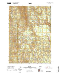
2020 Map of Hamelton Butte
USGS Topo · Published 2020About this map
Hamelton Butte rises as a prominent landmark along the boundary of Klamath and Lake counties in this 2020 survey of south-central Oregon. The landscape is defined by the high-elevation drainages of Sand Cr and Calahan Cr, which weave through the timbered slopes of Booth Ridge. This map documents a transitional mountain environment where water sources like Echo Spring and the open expanse of Stratton Meadow provide essential resources in an otherwise arid, high-altitude terrain. The grid of the Public Land Survey System is clearly marked, illustrating the division of townships including t31s r11e and t32s r12e. This modern topographic study is a primary resource for understanding the contemporary hydrology and relief of this remote border region, capturing the relationship between seasonal watercourses and the volcanic landforms characteristic of the area.
Find a feature on this map
14 named features on this map. Tap any name to fly to it.
Don’t see what you’re looking for? This feature index may not catch every label — zoom into the map to look around manually.
Map Details
Editions of this 2020 Hamelton Butte Map
This is the sole edition of this map. No revisions or reprints were ever made.
Other maps of this area

1889 · Klamath
USGS Topo · 1:250,000

1894 · Klamath
USGS Topo · 1:250,000

1955 · Klamath Falls
USGS Topo · 1:250,000

1958 · Klamath Falls
USGS Topo · 1:250,000

1960 · Riverbed Butte
USGS Topo · 1:62,500

1960 · Sycan Marsh
USGS Topo · 1:62,500

1960 · Fuego Mountain
USGS Topo · 1:62,500

1960 · Yamsay Mountain
USGS Topo · 1:62,500

1980 · Williamson River
USGS Topo · 1:100,000
1988 · Sycan Marsh West
USGS Topo · 1:24,000