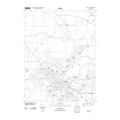
2010 Map of Hamilton
USGS Topo · Published 2010About this map
The Great Miami River carves through the heart of this landscape, anchoring the industrial and residential growth of Hamilton and its surrounding neighborhoods. This 2010 survey highlights a dense urban grid giving way to established suburban developments such as Brookwood, Highland Park, and Fairham Heights. Notable civic and cultural landmarks including the Fort Hamilton Monument, the Butler County Fairgrounds, and the Miami University Hamilton Campus speak to the area's role as a regional center.
Find a feature on this map
87 named features on this map. Tap any name to fly to it.
Don’t see what you’re looking for? This feature index may not catch every label — zoom into the map to look around manually.
Map Details
Editions of this 2010 Hamilton Map
This is the sole edition of this map. No revisions or reprints were ever made.
Other maps of this area

1904 · Mason
USGS Topo · 1:62,500

1906 · Mason
USGS Topo · 1:62,500

1908 · Miamisburg
USGS Topo · 1:62,500

1911 · Oxford
USGS Topo · 1:62,500

1915 · Hamilton
USGS Topo · 1:62,500

1917 · Hamilton
USGS Topo · 1:62,500

1953 · Cincinnati
USGS Topo · 1:250,000

1955 · Hamilton
USGS Topo · 1:24,000
1955 · Glendale
USGS Topo · 1:24,000
1955 · Trenton
USGS Topo · 1:24,000