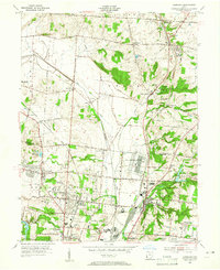
1955 Map of Glendale
USGS Topo · Published 1956About this map
Mill Creek and its tributaries carve a path through this mid-century landscape on the border of Butler and Hamilton Counties. The industrial and residential expansion of the mid-1950s is evident, as major rail lines including the Pennsylvania Railroad and Baltimore and Ohio Railroad converge near burgeoning communities. The area is marked by established institutional presence, such as the large US Reservation and numerous educational and religious centers like St Rita Sch and Glenmary Mission Cem.
Find a feature on this map
66 named features on this map. Tap any name to fly to it.
Don’t see what you’re looking for? This feature index may not catch every label — zoom into the map to look around manually.
Map Details
Editions of this 1955 Glendale Map
This is the sole edition of this map. No revisions or reprints were ever made.
Other maps of this area

1898 · East Cincinnati
USGS Topo · 1:62,500

1904 · Mason
USGS Topo · 1:62,500

1906 · Mason
USGS Topo · 1:62,500

1914 · East Cincinnati
USGS Topo · 1:62,500

1914 · West Cincinnati
USGS Topo · 1:62,500

1915 · Hamilton
USGS Topo · 1:62,500

1917 · Hamilton
USGS Topo · 1:62,500
1953 · Madeira
USGS Topo · 1:24,000
1953 · Cincinnati East
USGS Topo · 1:24,000

1953 · Cincinnati West
USGS Topo · 1:24,000