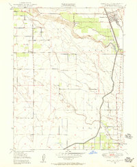
1949 Map of Hamilton City
USGS Topo · Published 1958About this map
Hamilton City stands as the primary hub in this agricultural landscape of northern Glenn County, as surveyed in 1949. The town's grid is situated near the northeast corner, bordered by the Southern Pacific railroad and the Central Irrigation Canal. This canal, along with the meandering course of Stony Creek, defines the water management and irrigation patterns critical to the surrounding orchards. The map highlights the localized nature of mid-century education with several rural schoolhouses serving the outlying areas, including Union High Sch, Plaza School, and Ord School.
Find a feature on this map
20 named features on this map. Tap any name to fly to it.
Don’t see what you’re looking for? This feature index may not catch every label — zoom into the map to look around manually.
Map Details
Editions of this 1949 Hamilton City Map
3 editions found
Other maps of this area

1891 · Chico
USGS Topo · 1:125,000

1893 · Chico
USGS Topo · 1:125,000

1895 · Chico
USGS Topo · 1:125,000

1904 · Vina
USGS Topo · 1:62,500

1906 · Willows
USGS Topo · 1:62,500

1912 · Nord
USGS Topo · 1:31,680

1912 · Chico Landing
USGS Topo · 1:31,680
1912 · Newhard
USGS Topo · 1:31,680

1914 · Kirkwood
USGS Topo · 1:31,680

1914 · Orland
USGS Topo · 1:31,680