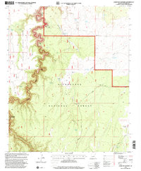
1998 Map of Hamilton Crossing
USGS Topo · Published 2001About this map
Sitgreaves National Forest and Coconino National Forest meet in this high-altitude landscape, where the plateaus of Blue Ridge Black Mesa give way to deep drainage systems. The map documents a sparse but deliberate network of ranching and land management infrastructure at the close of the twentieth century. Named family sites like Whitted Place and Echinique Place WT highlight the history of high-country grazing, supported by dozens of engineered water sources such as Surprise Tank and Stewart Tank. The namesake Hamilton Crossing sits on the western edge near the descent into the Clear Creek canyon. This topography is defined by its seasonal hydrology, where broad features like Echinique Draw and Tillman Draw channel water across the forest floor toward permanent drainages like Willow Creek. The presence of Tillman Road and numerous wind-powered wells, including the Ellsworth WT Well, points to the logistical effort required to maintain a presence in this remote Arizona interior.
Find a feature on this map
31 named features on this map. Tap any name to fly to it.
Don’t see what you’re looking for? This feature index may not catch every label — zoom into the map to look around manually.
Map Details
Editions of this 1998 Hamilton Crossing Map
This is the sole edition of this map. No revisions or reprints were ever made.
Other maps of this area

1886 · Holbrook
USGS Topo · 1:250,000

1887 · Verde
USGS Topo · 1:250,000

1892 · Verde
USGS Topo · 1:250,000

1893 · Holbrook
USGS Topo · 1:250,000

1954 · Holbrook
USGS Topo · 1:250,000

1955 · Sunset Knoll 2 SW
USGS Topo · 1:24,000

1955 · Sunset Knoll 2 SE
USGS Topo · 1:24,000

1955 · Sunset Pass
USGS Topo · 1:62,500

1957 · Holbrook
USGS Topo · 1:250,000

1958 · Holbrook
USGS Topo · 1:250,000