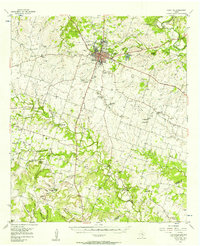
1956 Map of Hamilton
USGS Topo · Published 1957About this map
Hamilton serves as the hub of this Central Texas landscape, where the Leon River and Pecan Creek converge amidst a network of rural settlements. The mid-century infrastructure is characterized by the 36 Th Division Memorial Highway and the American Legion Memorial Highway, which overlay an older transit history evidenced by the Old Railroad Grade running through Aleman. Local education and community life are marked by several sites noted as being in transition, including the St Pauls Sch (Aband) and Liberty Sch (Aband), alongside the Rock House Sch (Historical). The terrain transitions from the river lowlands to prominent elevations like Vista Mountain and Dooley Mtn, with numerous family-named landmarks such as Jeffries Bridge and Parsley Crossing highlighting the importance of stream crossings in this agricultural region.
Find a feature on this map
71 named features on this map. Tap any name to fly to it.
Don’t see what you’re looking for? This feature index may not catch every label — zoom into the map to look around manually.
Map Details
Editions of this 1956 Hamilton Map
This is the sole edition of this map. No revisions or reprints were ever made.
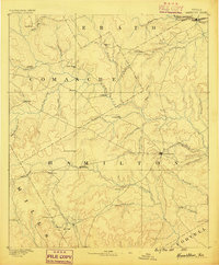
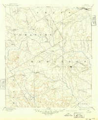
Historical Maps of Hamilton Through Time
3 maps found