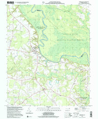
2002 Map of Hamilton
USGS Topo · Published 2002About this map
The Roanoke River snakes through the dense wetlands of Martin and Bertie Counties, defining a landscape of managed conservation and small agrarian settlements. Near the river's bend, the town of Hamilton serves as a primary hub, while smaller communities like Spring Green and Ballard dot the southern interior. The map illustrates a high density of rural religious life, with Lynch Chapel, Poplar Point Ch, and Roanoke Tabernacle anchoring the local crossroads. This area is characterized by vast protected territories, including the Roanoke River National Wildlife Refuge and the Roanoke River Wetlands State Game Land. The presence of the Edna Andrews Sch and various unmarked cemeteries provides valuable points of interest for those researching local family history or the development of rural education and community structures in this corner of North Carolina.
Find a feature on this map
25 named features on this map. Tap any name to fly to it.
Don’t see what you’re looking for? This feature index may not catch every label — zoom into the map to look around manually.
Map Details
Editions of this 2002 Hamilton Map
This is the sole edition of this map. No revisions or reprints were ever made.
Other maps of this area

1901 · Parmele
USGS Topo · 1:62,500

1901 · Williamston
USGS Topo · 1:62,500

1902 · Williamston
USGS Topo · 1:62,500

1902 · Parmele
USGS Topo · 1:62,500

1953 · Norfolk
USGS Topo · 1:250,000

1953 · Rocky Mount
USGS Topo · 1:250,000

1954 · Rocky Mount
USGS Topo · 1:250,000

1962 · Palmyra
USGS Topo · 1:24,000

1972 · Republican
USGS Topo · 1:24,000

1972 · Woodville
USGS Topo · 1:24,000