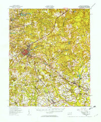
1949 Map of Hamlet
USGS Topo · Published 1954About this map
The Seaboard Air Line railway defines the industrial and social landscape of this post-war North Carolina and South Carolina borderland. Centered on the railroad hub of Hamlet, the map shows a network of trackage extending toward settlements like Old Hundred and Gibson. The landscape is densely packed with rural institutions that serve as vital markers for local historians, including numerous country schools such as Sneads Grove Sch and Baysville Sch, along with many family-named cemeteries and churches.
Find a feature on this map
102 named features on this map. Tap any name to fly to it.
Don’t see what you’re looking for? This feature index may not catch every label — zoom into the map to look around manually.
Map Details
Editions of this 1949 Hamlet Map
2 editions found

Other maps of this area

1942 · Troy
USGS Topo · 1:125,000

1942 · Rockingham
USGS Topo · 1:125,000

1948 · Southern Pines
USGS Topo · 1:62,500

1948 · Pinebluff
USGS Topo · 1:24,000

1949 · Gibson
USGS Topo · 1:24,000

1949 · Millstone Lake
USGS Topo · 1:24,000

1949 · Ghio
USGS Topo · 1:24,000

1949 · Laurinburg
USGS Topo · 1:24,000

1949 · Silver Hill
USGS Topo · 1:24,000

1949 · Hoffman
USGS Topo · 1:24,000