
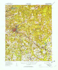
1949 Map of Hamlet
USGS Topo · Published 1954About this map
The railroad junction of Hamlet serves as the focal point of this late 1940s landscape, where the Seaboard Air Line tracks radiate out through the Sandhills. This era captures the town's height as a regional transportation hub, surrounded by satellite communities like North Hamlet, East Hamlet, and New Town. The map reveals a highly developed network of water bodies utilized for local industry and recreation, including Richmond Mill Lake, Ledbetter Lake, and numerous mill ponds such as Guinn's Mill Pond. Moving south and east toward Gibson and Laurel Hill, the terrain transitions into a more agricultural pattern dotted with family-named landmarks and rural institutions. Genealogists will find a wealth of specific locations such as Livingstons Quarters, Steen Town, and several schools including Sneads Grove School and Old Hundred School, marking a period before the consolidation of these smaller rural centers.
Find a feature on this map
111 named features on this map. Tap any name to fly to it.
Don’t see what you’re looking for? This feature index may not catch every label — zoom into the map to look around manually.
Map Details
Editions of this 1949 Hamlet Map
2 editions found
Other maps of this area

1942 · Troy
USGS Topo · 1:125,000

1942 · Rockingham
USGS Topo · 1:125,000

1948 · Southern Pines
USGS Topo · 1:62,500

1948 · Pinebluff
USGS Topo · 1:24,000

1949 · Gibson
USGS Topo · 1:24,000

1949 · Millstone Lake
USGS Topo · 1:24,000

1949 · Ghio
USGS Topo · 1:24,000

1949 · Laurinburg
USGS Topo · 1:24,000

1949 · Silver Hill
USGS Topo · 1:24,000

1949 · Hoffman
USGS Topo · 1:24,000