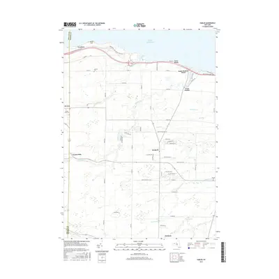
2016 Map of Hamlin
USGS Topo · Published 2016About this map
Lake Ontario defines the northern reaches of this coastal landscape, where the Lake Ontario State Pkwy follows the shoreline through Hamlin Beach State Park and the prominent headland at Devils Nose. The interior reflects a deeply rooted agricultural and rural residential pattern, anchored by the central village of Hamlin. Smaller historic nodes like Morton, Kendall Mills, and North Hamlin are scattered across a terrain drained by numerous waterways including Sandy Creek, Brush Cr, and West Cr. For those tracing local heritage, the map identifies several significant burying grounds such as Lakeside Cem, Morton Union Cem, and Moorman Cr Cem. The presence of the Brick Schoolhouse and the established road grid connecting lakefront communities like Sandy Harbour Beach to the interior town centers illustrates the 21st-century evolution of these lakefront settlements.
Find a feature on this map
68 named features on this map. Tap any name to fly to it.
Don’t see what you’re looking for? This feature index may not catch every label — zoom into the map to look around manually.
Map Details
Editions of this 2016 Hamlin Map
This is the sole edition of this map. No revisions or reprints were ever made.
Other maps of this area

1897 · Albion
USGS Topo · 1:62,500

1897 · Oak Orchard
USGS Topo · 1:62,500

1899 · Hamlin
USGS Topo · 1:62,500

1899 · Brockport
USGS Topo · 1:62,500

1932 · Hamlin
USGS Topo · 1:24,000

1932 · Spencerport
USGS Topo · 1:24,000

1934 · Spencerport
USGS Topo · 1:24,000

1934 · Brockport
USGS Topo · 1:24,000
1934 · Hilton
USGS Topo · 1:24,000

1935 · Hamlin
USGS Topo · 1:24,000