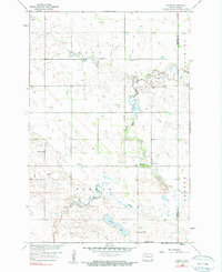
1958 Map of Hamlin
USGS Topo · Published 1990About this map
The Wild Rice River meanders across this rural landscape in southeastern North Dakota, serving as a primary geographical anchor between the townships of Hall and Herman. This late-1950s survey documents the agricultural character of the region, where isolated rural institutions like Immanuel Ch and several one-room schoolhouses, including School No 1 and School No 2, defined the community structure. The settlement of Hamlin sits at a critical junction near the river, accompanied by a small Landing Field that hints at the integration of aviation into rural mid-century life. Further south, the terrain transitions into a more water-laden environment characterized by Beere Lake and Murack Lake. The map also clearly delineates the border between Sargent Co and Richland Co, providing a precise record of property and political divisions during this era.
Find a feature on this map
14 named features on this map. Tap any name to fly to it.
Don’t see what you’re looking for? This feature index may not catch every label — zoom into the map to look around manually.
Map Details
Editions of this 1958 Hamlin Map
2 editions found
Other maps of this area

1907 · Wyndmere
USGS Topo · 1:125,000

1953 · Fargo
USGS Topo · 1:250,000

1956 · Fargo
USGS Topo · 1:250,000

1958 · Cayuga NW
USGS Topo · 1:24,000

1958 · Hamlin
USGS Topo · 1:24,000

1958 · Geneseo
USGS Topo · 1:24,000
1958 · Cayuga
USGS Topo · 1:24,000

1960 · Wyndmere
USGS Topo · 1:24,000

1960 · De Lamere
USGS Topo · 1:24,000

1960 · Milnor
USGS Topo · 1:24,000