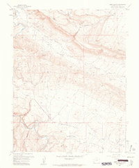
1960 Map of Hamm Canyon
USGS Topo · Published 1961About this map
The Dolores River winds through the western edge of this 1960 survey, cutting a path through the sandstone canyons of San Miguel County. The landscape is defined by the significant geological basins of Gypsum Valley and Disappointment Valley, which dominate the central and southern portions of the sheet. Between these valleys, a network of uranium and vanadium exploration is evident, marked by numerous small-scale mining operations including the Chile No 5 Mine, Mexico Mines, and the Sunday No 2 Mine. These claims follow the mineral-rich strata above Big Gypsum Creek, illustrating the era's intensive resource extraction. Distinctive landforms such as Cape Horn and Hamm Canyon overlook the tributary waters of Nicholas Wash and Mary Jane Draw, providing a detailed look at the drainage patterns before these remote drainages join Disappointment Creek.
Find a feature on this map
23 named features on this map. Tap any name to fly to it.
Don’t see what you’re looking for? This feature index may not catch every label — zoom into the map to look around manually.
Map Details
Editions of this 1960 Hamm Canyon Map
3 editions found
Other maps of this area

1916 · Paradox Valley
USGS Topo · 1:125,000

1922 · Paradox Valley
USGS Topo · 1:125,000

1948 · Bull Canyon
USGS Topo · 1:24,000

1948 · Horse Range Mesa
USGS Topo · 1:24,000

1948 · Hamm Canyon
USGS Topo · 1:24,000

1948 · Naturita NW
USGS Topo · 1:24,000

1948 · Gypsum Gap
USGS Topo · 1:24,000

1949 · Bull Canyon
USGS Topo · 1:24,000

1949 · Gypsum Gap
USGS Topo · 1:24,000

1949 · Naturita NW
USGS Topo · 1:24,000