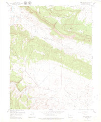
1960 Map of Hamm Canyon
USGS Topo · Published 1979About this map
The Dolores River winds through the western edge of this San Miguel County landscape, defining a region of intense geologic transition and mineral exploration. In the mid-century era, the terrain between Gypsum Valley and Disappointment Valley was a hub of mining activity, with numerous sites such as the Chile No 5 Mine, Mexico Mines, and the Maggie No 2 Mine scattered across the ridges. The extraction economy is further evidenced by a prominent Pipeline and several Oil Wells located near Hamm Canyon.
Find a feature on this map
24 named features on this map. Tap any name to fly to it.
Don’t see what you’re looking for? This feature index may not catch every label — zoom into the map to look around manually.
Map Details
Editions of this 1960 Hamm Canyon Map
3 editions found
Other maps of this area

1916 · Paradox Valley
USGS Topo · 1:125,000

1922 · Paradox Valley
USGS Topo · 1:125,000

1948 · Bull Canyon
USGS Topo · 1:24,000

1948 · Horse Range Mesa
USGS Topo · 1:24,000

1948 · Hamm Canyon
USGS Topo · 1:24,000

1948 · Naturita NW
USGS Topo · 1:24,000

1948 · Gypsum Gap
USGS Topo · 1:24,000

1949 · Bull Canyon
USGS Topo · 1:24,000

1949 · Gypsum Gap
USGS Topo · 1:24,000

1949 · Naturita NW
USGS Topo · 1:24,000