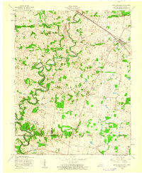
1957 Map of Hammacksville
USGS Topo · Published 1960About this map
The West Fork Red River carves a winding path through this 1957 study of the Kentucky and Tennessee borderlands. The landscape is defined by its rural infrastructure, anchored by the Louisville and Nashville railroad which connects the town of Trenton to the broader regional economy. This era reveals a network of small social and educational centers, most notably the Rosenwald Sch, a significant site for local history and African American education, and the Barkers Mill Community House near the Woodward Dam.
Find a feature on this map
22 named features on this map. Tap any name to fly to it.
Don’t see what you’re looking for? This feature index may not catch every label — zoom into the map to look around manually.
Map Details
Editions of this 1957 Hammacksville Map
This is the sole edition of this map. No revisions or reprints were ever made.
Other maps of this area

1944 · Clarksville
USGS Topo · 1:50,000

1950 · Guthrie
USGS Topo · 1:24,000

1950 · Pembroke
USGS Topo · 1:24,000

1951 · Pembroke
USGS Topo · 1:24,000

1951 · Elkton
USGS Topo · 1:24,000

1951 · Hopkinsville
USGS Topo · 1:24,000

1951 · New Providence
USGS Topo · 1:24,000

1951 · Hammacksville
USGS Topo · 1:24,000

1951 · Clarksville
USGS Topo · 1:24,000

1951 · Oak Grove
USGS Topo · 1:24,000