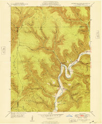
1948 Map of Hammersley Fork
USGS Topo · Published 1948About this map
Kettle Creek winds through the heart of the Pennsylvania Wilds in this late 1940s survey, illustrating a landscape defined by deep-cut hollows and small riverside communities. Along the creek's dramatic turns, such as the sharp curve of Oxbow Bend, settlements like Hammersley Fork and Leidy represent the primary points of human habitation. The map reveals a tight-knit rural infrastructure, marked by the Central Sch and the Gospel Camp Ch near the junction of Page Run.
Find a feature on this map
69 named features on this map. Tap any name to fly to it.
Don’t see what you’re looking for? This feature index may not catch every label — zoom into the map to look around manually.
Map Details
Editions of this 1948 Hammersley Fork Map
2 editions found
Other maps of this area

1945 · Driftwood
USGS Topo · 1:48,000

1945 · First Fork
USGS Topo · 1:24,000

1945 · Sinnemahoning
USGS Topo · 1:24,000

1946 · Renovo West
USGS Topo · 1:62,500

1946 · Hammersley Fork
USGS Topo · 1:24,000

1946 · Keating
USGS Topo · 1:24,000

1946 · Tamarack
USGS Topo · 1:24,000

1946 · Renovo West
USGS Topo · 1:24,000

1947 · First Fork
USGS Topo · 1:24,000

1947 · Sinnemahoning
USGS Topo · 1:24,000
Featured Places
- Leidy Township, PA
- Wharton Township, PA
- East Keating Township, PA
- Grove Township, PA
- Hammersley Fork, Leidy Township