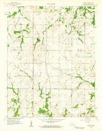
1958 Map of Hammond
USGS Topo · Published 1959About this map
St Louis San Francisco railroad tracks anchor the small settlement of Hammond in Bourbon County, Kansas, cutting a diagonal path through the prairie landscape. The area is defined by its rural civic structure, where every few miles reveals a local schoolhouse or church, including Glendale Ch and the West Liberty Sch. These small, localized institutions served a dispersed farming population that relied on the fertile bottomlands near the Little Osage River and Wolverine Creek.
Find a feature on this map
19 named features on this map. Tap any name to fly to it.
Don’t see what you’re looking for? This feature index may not catch every label — zoom into the map to look around manually.
Map Details
Editions of this 1958 Hammond Map
2 editions found
Other maps of this area

1884 · Fort Scott
USGS Topo · 1:125,000

1886 · Fort Scott
USGS Topo · 1:125,000

1887 · Mound City
USGS Topo · 1:125,000

1893 · Fort Scott
USGS Topo · 1:125,000

1893 · Mound City
USGS Topo · 1:125,000

1939 · Deerfield
USGS Topo · 1:24,000

1940 · Hume
USGS Topo · 1:24,000

1942 · Hume
USGS Topo · 1:24,000

1942 · Richards
USGS Topo · 1:24,000

1942 · Deerfield
USGS Topo · 1:24,000