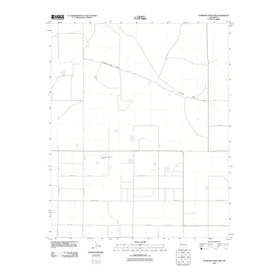
2010 Map of Hammond Ranch SW
USGS Topo · Published 2010About this map
Running Water Draw cuts through the high plains of Curry County, creating a natural drainage pattern across an otherwise strictly gridded landscape of agricultural roads and section lines. This 2010 survey illustrates the intersection of rural aviation and commercial farming, centered around the Lockmiller and Sons Airport. The map's geometric layout is defined by a dense network of local thoroughfares, including Curry Road 17 and Curry Road 22, which facilitate the transport of goods in this corner of eastern New Mexico. Small, scattered water features dot the acreage between the section lines, reflecting the region's reliance on intermittent water sources and the organized management of prairie land in the early twenty-first century.
Find a feature on this map
23 named features on this map. Tap any name to fly to it.
Don’t see what you’re looking for? This feature index may not catch every label — zoom into the map to look around manually.
Map Details
Editions of this 2010 Hammond Ranch SW Map
This is the sole edition of this map. No revisions or reprints were ever made.
Other maps of this area

1954 · Clovis
USGS Topo · 1:250,000

1957 · Portair
USGS Topo · 1:62,500

1957 · Melrose
USGS Topo · 1:62,500

1957 · Hammond Ranch
USGS Topo · 1:62,500

1958 · Clovis
USGS Topo · 1:250,000

1972 · Melrose East
USGS Topo · 1:24,000

1973 · Field SE
USGS Topo · 1:24,000
1973 · Field
USGS Topo · 1:24,000

1985 · Portair
USGS Topo · 1:24,000

1985 · Smith Ranch
USGS Topo · 1:24,000