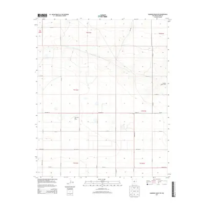
2013 Map of Hammond Ranch SW
USGS Topo · Published 2013About this map
Lockmiller & Sons Airport serves as a central landmark in this high plains landscape of eastern New Mexico, where the terrain is defined by a rigorous grid of section lines and township boundaries. The map area is dominated by agricultural development, with an extensive network of rural roads such as Co Road 25, Co Road AB, and Co Road U facilitating transport across the Llano Estacado. The natural topography is subtly shaped by Running Water Draw, an ephemeral drainage feature that cuts across the northeastern portion of the quadrangle. In the southern half, State Route 311 provides a primary east-west corridor, intersecting with several lettered and numbered county routes. This 2013 survey illustrates the modern configuration of large-scale land parcels and local aviation infrastructure near the Texas border.
Find a feature on this map
26 named features on this map. Tap any name to fly to it.
Don’t see what you’re looking for? This feature index may not catch every label — zoom into the map to look around manually.
Map Details
Editions of this 2013 Hammond Ranch SW Map
This is the sole edition of this map. No revisions or reprints were ever made.
Other maps of this area

1954 · Clovis
USGS Topo · 1:250,000

1957 · Portair
USGS Topo · 1:62,500

1957 · Melrose
USGS Topo · 1:62,500

1957 · Hammond Ranch
USGS Topo · 1:62,500

1958 · Clovis
USGS Topo · 1:250,000

1972 · Melrose East
USGS Topo · 1:24,000

1973 · Field SE
USGS Topo · 1:24,000
1973 · Field
USGS Topo · 1:24,000

1985 · Portair
USGS Topo · 1:24,000

1985 · Smith Ranch
USGS Topo · 1:24,000