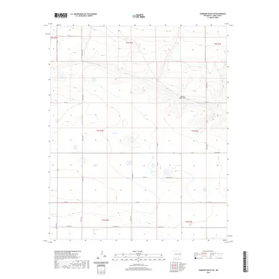
2020 Map of Hammond Ranch SW
USGS Topo · Published 2020About this map
Running Water Draw carves a subtle path through this section of the High Plains, illustrating the hydrological patterns of eastern New Mexico. This 2020 survey of Curry County documents an expansive agricultural and ranching landscape organized by a rigorous grid of section lines and county roads. Significant transit corridors like Curry Road Z, Curry Road 17, and Curry Road X divide the terrain into massive blocks, typical of the regional land management. The drainage features and scattered depressions shown here reveal the natural topography that underlies the man-made boundaries of t5n r33e and t4n r34e. This map serves as a primary record of the modern rural infrastructure and water management in a part of the state where the legacy of the Public Land Survey System remains the dominant structural element of the landscape.
Find a feature on this map
20 named features on this map. Tap any name to fly to it.
Don’t see what you’re looking for? This feature index may not catch every label — zoom into the map to look around manually.
Map Details
Editions of this 2020 Hammond Ranch SW Map
This is the sole edition of this map. No revisions or reprints were ever made.
Other maps of this area

1954 · Clovis
USGS Topo · 1:250,000

1957 · Portair
USGS Topo · 1:62,500

1957 · Melrose
USGS Topo · 1:62,500

1957 · Hammond Ranch
USGS Topo · 1:62,500

1958 · Clovis
USGS Topo · 1:250,000

1972 · Melrose East
USGS Topo · 1:24,000

1973 · Field SE
USGS Topo · 1:24,000
1973 · Field
USGS Topo · 1:24,000

1985 · Portair
USGS Topo · 1:24,000

1985 · Smith Ranch
USGS Topo · 1:24,000