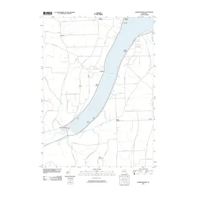
2010 Map of Hammondsport
USGS Topo · Published 2010About this map
Keuka Lake serves as the central anchor of this landscape, its western fork dominated by a tradition of viticulture. The presence of Heron Hill Winery and Bully Hill Vineyards on the slopes above the water highlights the regional importance of the wine industry. At the southern tip of the lake, the village of Hammondsport sits at the mouth of Keuka Inlet, acting as a historic gateway for both maritime and terrestrial traffic.
Find a feature on this map
49 named features on this map. Tap any name to fly to it.
Don’t see what you’re looking for? This feature index may not catch every label — zoom into the map to look around manually.
Map Details
Editions of this 2010 Hammondsport Map
This is the sole edition of this map. No revisions or reprints were ever made.
Other maps of this area

1900 · Naples
USGS Topo · 1:62,500

1903 · Naples
USGS Topo · 1:62,500

1903 · Penn Yan
USGS Topo · 1:62,500

1903 · Hammondsport
USGS Topo · 1:62,500

1910 · Bath
USGS Topo · 1:62,500

1913 · Naples
USGS Topo · 1:62,500

1942 · Prattsburg
USGS Topo · 1:31,680

1942 · Pulteney
USGS Topo · 1:31,680

1942 · Keuka Park
USGS Topo · 1:24,000

1943 · Keuka Lake
USGS Topo · 1:31,680