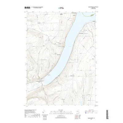
2019 Map of Hammondsport
USGS Topo · Published 2019About this map
Hammondsport sits at the southern tip of Keuka Lake, serving as the gateway to this Finger Lakes landscape where the shoreline is defined by points such as Oak Point and Willow Point. The village street grid and the nearby Loucks Airport contrast with the steep, ridge-climbing roads like Greyton H Taylor Memorial Dr and Urbana Rd. Local history is preserved in small hillside burial grounds including Depew Wixon Cem and Chestnut Grove Cem, while the larger Elmwood Cem sits near the village center. Small lakeside settlements such as Urbana and Glen Grove illustrate the residential development along W Lake Rd, while higher elevations host scattered communities like South Pulteney and Elmbois. The topography transitions from the alluvial flat at Keuka Inlet to the high ground of Mt Washington and Wixom Hill, following the drainage of Glen Brook and Smith Run.
Find a feature on this map
71 named features on this map. Tap any name to fly to it.
Don’t see what you’re looking for? This feature index may not catch every label — zoom into the map to look around manually.
Map Details
Editions of this 2019 Hammondsport Map
This is the sole edition of this map. No revisions or reprints were ever made.
Other maps of this area

1900 · Naples
USGS Topo · 1:62,500

1903 · Naples
USGS Topo · 1:62,500

1903 · Penn Yan
USGS Topo · 1:62,500

1903 · Hammondsport
USGS Topo · 1:62,500

1910 · Bath
USGS Topo · 1:62,500

1913 · Naples
USGS Topo · 1:62,500

1942 · Prattsburg
USGS Topo · 1:31,680

1942 · Pulteney
USGS Topo · 1:31,680

1942 · Keuka Park
USGS Topo · 1:24,000

1943 · Keuka Lake
USGS Topo · 1:31,680