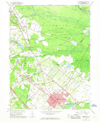
1966 Map of Hammonton
USGS Topo · Published 1968About this map
The Pennsylvania-Reading Seashore Lines define the transportation corridor of this Pine Barrens region, linking the township of Hammonton with outlying settlements like Chesilhurst and Winslow. The landscape is characterized by the expansive Wharton State Forest and complex drainage systems including Great Swamp Branch and Blue Anchor Brook. This mid-century survey captures the area as the Atlantic City Expressway began to reshape local transit alongside traditional routes like the Old White Horse Pike. Notable institutional landmarks, such as the Ancora State Hospital, occupy significant acreage amidst the dense network of named branches and creeks. Genealogists will find numerous burial sites documented, including Waterford Cem and Oak Grove Cem, while local historians can trace the footprints of early industry at the Gravel Pit or recreation at Hammonton Lake Park.
Find a feature on this map
90 named features on this map. Tap any name to fly to it.
Don’t see what you’re looking for? This feature index may not catch every label — zoom into the map to look around manually.
Map Details
Editions of this 1966 Hammonton Map
4 editions found
Other maps of this area

1888 · Pemberton
USGS Topo · 1:62,500

1888 · Mount Holly
USGS Topo · 1:62,500

1890 · Hammonton
USGS Topo · 1:62,500

1890 · Mullica
USGS Topo · 1:62,500

1894 · Hammonton
USGS Topo · 1:62,500

1894 · Pemberton
USGS Topo · 1:62,500

1894 · Mount Holly
USGS Topo · 1:62,500

1894 · Mullica
USGS Topo · 1:62,500

1898 · Pemberton
USGS Topo · 1:62,500

1898 · Mount Holly
USGS Topo · 1:62,500