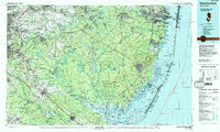
1984 Map of Hammonton
USGS Topo · Published 1988About this map
The Pine Barrens and the Jersey Shore dominate this 1980s landscape, illustrating a region defined by extensive public lands and coastal marsh systems. Wharton State Forest and Lebanon State Forest cover a significant portion of the interior, preserving the characteristic pine-oak ecology of southern New Jersey. In the west, the growth of suburban centers like Mount Laurel and Cherry Hill contrasts with the preserved wildness of the Mullica River and Wading River drainages. To the east, the barrier islands of Island Beach and Long Beach Island frame Barnegat Bay and Little Egg Harbor. This survey documents a critical period for conservation, showing the established boundaries of the Edwin B. Forsythe National Wildlife Refuge alongside major transportation corridors like the Garden State Parkway and the Atlantic City Expressway. Significant institutional landmarks are also noted, including Stockton State College and the Fort Dix Military Reservation northern boundary.
Find a feature on this map
194 named features on this map. Tap any name to fly to it.
Don’t see what you’re looking for? This feature index may not catch every label — zoom into the map to look around manually.
Map Details
Editions of this 1984 Hammonton Map
3 editions found
Other maps of this area

1884 · Whitings
USGS Topo · 1:62,500

1887 · Atlantic City
USGS Topo · 1:62,500

1888 · Bordentown
USGS Topo · 1:62,500

1888 · Pemberton
USGS Topo · 1:62,500

1888 · Barnegat
USGS Topo · 1:62,500

1888 · Little Egg Harbor
USGS Topo · 1:62,500

1888 · Mount Holly
USGS Topo · 1:62,500

1888 · Asbury Park
USGS Topo · 1:62,500

1888 · Cassville
USGS Topo · 1:62,500

1888 · Long Beach
USGS Topo · 1:62,500
Featured Places
- Toms River, NJ
- Cherry Hill Township, NJ
- Vineland, NJ
- Jackson Township, NJ
- Sicklerville, Winslow Township