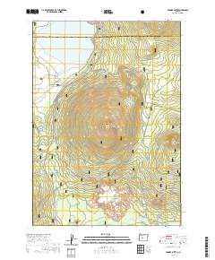
2020 Map of Hamner Butte
USGS Topo · Published 2020About this map
Deschutes National Forest encompasses the volcanic peaks and watershed patterns of the high Cascades on this 2020 topographic record. The landscape is dominated by the prominent shield-like form of Hamner Butte and the surrounding heights of Saddle Butte, Ringo Butte, and Davis Mtn. Along the northern edge, the waters of Davis Lake are fed by Ranger Cr and Odell Cr, while the southern reaches are marked by the winding path of Crescent Cr near the Black Rock formation.
Find a feature on this map
22 named features on this map. Tap any name to fly to it.
Don’t see what you’re looking for? This feature index may not catch every label — zoom into the map to look around manually.
Map Details
Editions of this 2020 Hamner Butte Map
This is the sole edition of this map. No revisions or reprints were ever made.
Other maps of this area

1930 · Maiden Peak
USGS Topo · 1:125,000

1934 · Maiden Peak
USGS Topo · 1:125,000

1935 · Chemult
USGS Topo · 1:96,000

1941 · Chemult
USGS Topo · 1:125,000

1955 · Crescent
USGS Topo · 1:250,000

1957 · Crescent
USGS Topo · 1:250,000

1958 · Crescent
USGS Topo · 1:250,000

1963 · Hamner Butte
USGS Topo · 1:24,000
1963 · The Twins
USGS Topo · 1:24,000
1963 · Odell Lake
USGS Topo · 1:24,000