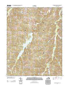
2013 Map of Hampden Sydney
USGS Topo · Published 2013About this map
Hampden Sydney defines the northern landscape of this region, home to the sprawling campus grounds including Fraternity Circle, the Athletic Complex, and residential areas like Hampden House Units and Penshurst Lawn. This collegiate hub is surrounded by older rural communities such as Kingsville and Worsham, which sit at the intersection of local routes leading toward the Providence Airport. The terrain is characterized by a complex network of waterways, with the Bush River and its many tributaries, such as Briery Cr and Rice Cr, cutting through the Prince Edward County countryside.
Find a feature on this map
82 named features on this map. Tap any name to fly to it.
Don’t see what you’re looking for? This feature index may not catch every label — zoom into the map to look around manually.
Map Details
Editions of this 2013 Hampden Sydney Map
This is the sole edition of this map. No revisions or reprints were ever made.
Other maps of this area

1891 · Farmville
USGS Topo · 1:125,000

1892 · Appomattox
USGS Topo · 1:125,000

1893 · Farmville
USGS Topo · 1:125,000

1947 · Roanoke
USGS Topo · 1:250,000

1956 · Charlotte Court House
USGS Topo · 1:62,500

1958 · Farmville
USGS Topo · 1:62,500

1958 · Keysville
USGS Topo · 1:62,500

1958 · Pamplin City
USGS Topo · 1:62,500

1959 · Roanoke
USGS Topo · 1:250,000

1963 · Roanoke
USGS Topo · 1:250,000
Featured Places
- Hampden Sydney, VA
- Kingsville, Hampden Sydney
- Worsham, Hampden Sydney
- Prince Edward County, VA
- United States